IMAGES TAKEN NEAR TO
Sidlaw Place, KILMARNOCK, KA1 3UN
Introduction
This page details the photographs taken nearby to Sidlaw Place, KA1 3UN by members of the Geograph project.
The Geograph project started in 2005 with the aim of publishing, organising and preserving representative images for every square kilometre of Great Britain, Ireland and the Isle of Man.

There are currently over 7.5m images from over14,400 individuals and you can help contribute to the project by visiting https://www.geograph.org.uk
Image Map
Images are licensed for reuse under creativecommons.org/licenses/by-sa/2.0
Notes
- Clicking on the map will re-center to the selected point.
- The higher the marker number, the further away the image location is from the centre of the postcode.
Image Listing (13 Images Found)
Images are licensed for reuse under creativecommons.org/licenses/by-sa/2.0
Image
Details
Distance
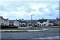
1
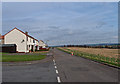
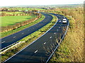
Grampian Road, Bellfield, Kilmarnock
Eastern side of Kilmarnock. The A77 on the right.
Image: © wfmillar
Taken: 6 Mar 2012
0.03 miles
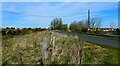
3
The Edge of Kilmarnock
Treeswoodhead Road
Image: © Iain Thompson
Taken: 8 Dec 2006
0.05 miles
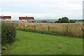
6
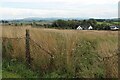
Bridgehouse Farm, South of Kilmarnock
The fence is the boundary of the built up area.
Image: © Alan Reid
Taken: 15 Sep 2021
0.18 miles
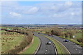
7

Inchbean Farm
View from the minor road bridge over the A77. A pause in the rain.
Image: © wfmillar
Taken: 2 Apr 2012
0.19 miles
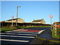
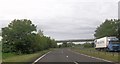
8
The minor road rises to cross the bridge over the A77
Image: © Gordon Brown
Taken: 23 Apr 2021
0.19 miles
10
Kilmarnock - 1972
Kilmarnock, Dumgoyne Road seen from Lammermuir Road
Image: © Helmut Zozmann
Taken: 2 Jul 1972
0.22 miles