IMAGES TAKEN NEAR TO
Haining Avenue, KILMARNOCK, KA1 3PT
Introduction
This page details the photographs taken nearby to Haining Avenue, KA1 3PT by members of the Geograph project.
The Geograph project started in 2005 with the aim of publishing, organising and preserving representative images for every square kilometre of Great Britain, Ireland and the Isle of Man.

There are currently over 7.5m images from over14,400 individuals and you can help contribute to the project by visiting https://www.geograph.org.uk
Image Map
Images are licensed for reuse under creativecommons.org/licenses/by-sa/2.0
Notes
- Clicking on the map will re-center to the selected point.
- The higher the marker number, the further away the image location is from the centre of the postcode.
Image Listing (9 Images Found)
Images are licensed for reuse under creativecommons.org/licenses/by-sa/2.0
Image
Details
Distance
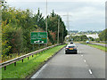
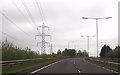
2
Junction of the A71 and the A77 near Riccarton
Image: © Andrew Abbott
Taken: 15 May 2010
0.14 miles
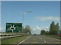
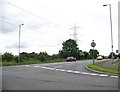
4
A71 approaching roundabout south of Kilmarnock
This is the junction of the A71, A76 and A735
Image: © John Firth
Taken: 19 May 2013
0.16 miles
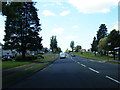
5
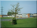
Kirkstyle Primary School
Kirkstyle Primary School is a non-denomination school situated South of Kilmatnock
Image: © Ian Rainey
Taken: 8 May 2006
0.22 miles
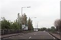
7
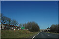
By Bellfield
Another view along the A77.
Image: © Malcolm Neal
Taken: 20 Mar 2022
0.23 miles
8

A735 on a wet Sunday evening
Light industrial units predominate on this entry to Kilmarnock.
Image: © Peter Whatley
Taken: 20 Sep 2015
0.23 miles