IMAGES TAKEN NEAR TO
Hurlford Road, KILMARNOCK, KA1 3NL
Introduction
This page details the photographs taken nearby to Hurlford Road, KA1 3NL by members of the Geograph project.
The Geograph project started in 2005 with the aim of publishing, organising and preserving representative images for every square kilometre of Great Britain, Ireland and the Isle of Man.

There are currently over 7.5m images from over14,400 individuals and you can help contribute to the project by visiting https://www.geograph.org.uk
Image Map
Images are licensed for reuse under creativecommons.org/licenses/by-sa/2.0
Notes
- Clicking on the map will re-center to the selected point.
- The higher the marker number, the further away the image location is from the centre of the postcode.
Image Listing (24 Images Found)
Images are licensed for reuse under creativecommons.org/licenses/by-sa/2.0
Image
Details
Distance
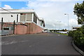
1
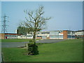
Kirkstyle Primary School
Kirkstyle Primary School is a non-denomination school situated South of Kilmatnock
Image: © Ian Rainey
Taken: 8 May 2006
0.08 miles
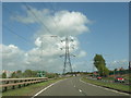
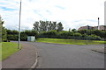
3
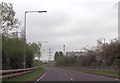
Factories and Power lines adjacent to A71
East of Riccarton junction
Image: © John Firth
Taken: 19 May 2013
0.17 miles
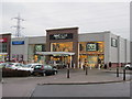
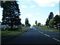
7
Road passing ASDA, Kilmarnock
Road part of a bus route.
Image: © Billy McCrorie
Taken: 21 Aug 2013
0.20 miles
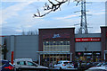
8
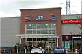
b&m at Queens Drive Retail Park, Kilmarnock
Image: © Billy McCrorie
Taken: 29 Aug 2017
0.21 miles
10
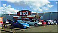
Kilmarnock's B&Q
One of the retail outlets in the large business park off Queen's Drive.
Image: © Mary and Angus Hogg
Taken: 5 Mar 2017
0.22 miles