IMAGES TAKEN NEAR TO
Sturrock Street, KILMARNOCK, KA1 3AH
Introduction
This page details the photographs taken nearby to Sturrock Street, KA1 3AH by members of the Geograph project.
The Geograph project started in 2005 with the aim of publishing, organising and preserving representative images for every square kilometre of Great Britain, Ireland and the Isle of Man.

There are currently over 7.5m images from over14,400 individuals and you can help contribute to the project by visiting https://www.geograph.org.uk
Image Map
Images are licensed for reuse under creativecommons.org/licenses/by-sa/2.0
Notes
- Clicking on the map will re-center to the selected point.
- The higher the marker number, the further away the image location is from the centre of the postcode.
Image Listing (236 Images Found)
Images are licensed for reuse under creativecommons.org/licenses/by-sa/2.0
Image
Details
Distance
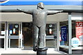
2
The Salvation Army Church and Community Centre, Kilmarnock
Image: © JThomas
Taken: 21 May 2021
0.04 miles
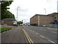
3
Sturrock Street (A735), Kilmarnock
Heading south towards the junction with the A759.
Image: © JThomas
Taken: 21 May 2021
0.06 miles
4
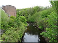
Kilmarnock Water
Looking east from the bridge on Sturrock Street.
Image: © JThomas
Taken: 21 May 2021
0.06 miles
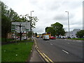
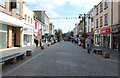
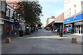
5
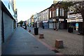
King Street, Kilmarnock
The pedestrianised shopping street in the middle of Kilmarnock.
Image: © Graham Robson
Taken: 27 Jun 2019
0.06 miles
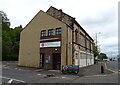
9
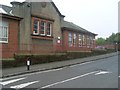
Former St Columba's Primary School
In Kilmarnock.
Image: © Stephen Sweeney
Taken: 12 Oct 2010
0.07 miles