IMAGES TAKEN NEAR TO
KILWINNING, KA13 7RX
Introduction
This page details the photographs taken nearby to KA13 7RX by members of the Geograph project.
The Geograph project started in 2005 with the aim of publishing, organising and preserving representative images for every square kilometre of Great Britain, Ireland and the Isle of Man.

There are currently over 7.5m images from over14,400 individuals and you can help contribute to the project by visiting https://www.geograph.org.uk
Image Map
Images are licensed for reuse under creativecommons.org/licenses/by-sa/2.0
Notes
- Clicking on the map will re-center to the selected point.
- The higher the marker number, the further away the image location is from the centre of the postcode.
Image Listing (17 Images Found)
Images are licensed for reuse under creativecommons.org/licenses/by-sa/2.0
Image
Details
Distance
1
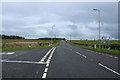
Entrance to Torranyard Caravan Park
Pictured Monday 3rd August 1.10pm
Image: © Gordon Dowie
Taken: 3 Aug 2009
0.02 miles
2
Torranyard Caravan park
View from near entrance to Caravan park looking towards A736
Image: © Docsavage
Taken: 13 May 2009
0.04 miles
6
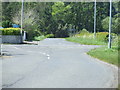
Torranyard junction
Looking west towards Torranyard junction, main road is (A736)
Image: © Docsavage
Taken: 13 May 2009
0.08 miles
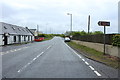
7
A737 at Torranyard
Road sign at Torranyard. 3rd August 2009 1.15pm
Image: © Gordon Dowie
Taken: 3 Aug 2009
0.10 miles
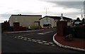
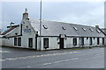
8
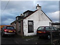
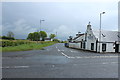
Former tollhouse
Surveyed by the Milestone Society. On the A756 between Irvine and Barrhead near the minor cross roads in Torranyard.
Image: © Chris Minto
Taken: 28 Oct 2013
0.10 miles
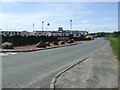
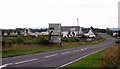
9
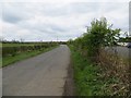
Road, Torranyard
The road is passing a caravan park.
Image: © Richard Webb
Taken: 25 Apr 2014
0.11 miles