IMAGES TAKEN NEAR TO
Auchentiber, KILWINNING, KA13 7RR
Introduction
This page details the photographs taken nearby to Auchentiber, KA13 7RR by members of the Geograph project.
The Geograph project started in 2005 with the aim of publishing, organising and preserving representative images for every square kilometre of Great Britain, Ireland and the Isle of Man.

There are currently over 7.5m images from over14,400 individuals and you can help contribute to the project by visiting https://www.geograph.org.uk
Image Map
Images are licensed for reuse under creativecommons.org/licenses/by-sa/2.0
Notes
- Clicking on the map will re-center to the selected point.
- The higher the marker number, the further away the image location is from the centre of the postcode.
Image Listing (16 Images Found)
Images are licensed for reuse under creativecommons.org/licenses/by-sa/2.0
Image
Details
Distance
1
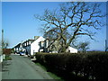
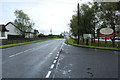
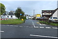
Tree and Houses
This photo shows about half the houses in Auchentiber
Image: © Ian Rainey
Taken: 28 Apr 2006
0.02 miles
3
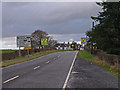
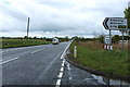
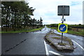
Road Junction Auchentiber
I counted eight Give Way signs plus on road markings approaching this junction of the B788/A736. Could it be the drivers nowadays cannot read?
Image: © wfmillar
Taken: 20 Nov 2009
0.04 miles