IMAGES TAKEN NEAR TO
Auchentiber, KILWINNING, KA13 7RP
Introduction
This page details the photographs taken nearby to Auchentiber, KA13 7RP by members of the Geograph project.
The Geograph project started in 2005 with the aim of publishing, organising and preserving representative images for every square kilometre of Great Britain, Ireland and the Isle of Man.

There are currently over 7.5m images from over14,400 individuals and you can help contribute to the project by visiting https://www.geograph.org.uk
Image Map
Images are licensed for reuse under creativecommons.org/licenses/by-sa/2.0
Notes
- Clicking on the map will re-center to the selected point.
- The higher the marker number, the further away the image location is from the centre of the postcode.
Image Listing (2 Images Found)
Images are licensed for reuse under creativecommons.org/licenses/by-sa/2.0
Image
Details
Distance
1
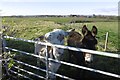
Donkeys, Wardlaw
View through the ears towards Auchentiber.
Image: © Richard Webb
Taken: 6 Nov 2016
0.08 miles
2
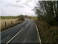
B778 towards Wardlaw
Heading east along the B778 with Wardlaw, the next farm, on the horizon.
Image: © Mark Nightingale
Taken: 23 Mar 2010
0.25 miles