IMAGES TAKEN NEAR TO
Montgreenan, KILWINNING, KA13 7RL
Introduction
This page details the photographs taken nearby to Montgreenan, KA13 7RL by members of the Geograph project.
The Geograph project started in 2005 with the aim of publishing, organising and preserving representative images for every square kilometre of Great Britain, Ireland and the Isle of Man.

There are currently over 7.5m images from over14,400 individuals and you can help contribute to the project by visiting https://www.geograph.org.uk
Image Map
Images are licensed for reuse under creativecommons.org/licenses/by-sa/2.0
Notes
- Clicking on the map will re-center to the selected point.
- The higher the marker number, the further away the image location is from the centre of the postcode.
Image Listing (5 Images Found)
Images are licensed for reuse under creativecommons.org/licenses/by-sa/2.0
Image
Details
Distance
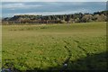
1
Cottages
Farmland view to white painted cottages.
Image: © Chris Court
Taken: 23 Dec 2005
0.06 miles
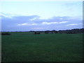
2
Farmland, Fergushill Hall
Looking over the lush grass towards Fergushill Hall.
Image: © wfmillar
Taken: 9 Sep 2009
0.10 miles
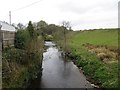
4
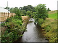
Burn behind Cottage
Picture taken from the road bridge over the Lugton Water looking West. New close boarded fencing recently erected behind the cottage. 3rd August 2009 1.20pm
Image: © Gordon Dowie
Taken: 3 Aug 2009
0.14 miles