IMAGES TAKEN NEAR TO
KILWINNING, KA13 7RH
Introduction
This page details the photographs taken nearby to KA13 7RH by members of the Geograph project.
The Geograph project started in 2005 with the aim of publishing, organising and preserving representative images for every square kilometre of Great Britain, Ireland and the Isle of Man.

There are currently over 7.5m images from over14,400 individuals and you can help contribute to the project by visiting https://www.geograph.org.uk
Image Map
Images are licensed for reuse under creativecommons.org/licenses/by-sa/2.0
Notes
- Clicking on the map will re-center to the selected point.
- The higher the marker number, the further away the image location is from the centre of the postcode.
Image Listing (2 Images Found)
Images are licensed for reuse under creativecommons.org/licenses/by-sa/2.0
Image
Details
Distance
1
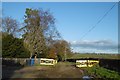
Barriers, Clonbeith Castle
Ready to block the road when the cows are walking. A yellow road passes a dairy farm.
Image: © Richard Webb
Taken: 6 Nov 2016
0.04 miles
2
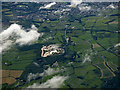
Hullerhill sand quarry from the air
On the outskirts of Kilwinning. Operated by Hugh King & Co http://www.hughking.co.uk/ .
Image: © Thomas Nugent
Taken: 19 Jun 2017
0.22 miles