IMAGES TAKEN NEAR TO
KILWINNING, KA13 7RB
Introduction
This page details the photographs taken nearby to KA13 7RB by members of the Geograph project.
The Geograph project started in 2005 with the aim of publishing, organising and preserving representative images for every square kilometre of Great Britain, Ireland and the Isle of Man.

There are currently over 7.5m images from over14,400 individuals and you can help contribute to the project by visiting https://www.geograph.org.uk
Image Map
Images are licensed for reuse under creativecommons.org/licenses/by-sa/2.0
Notes
- Clicking on the map will re-center to the selected point.
- The higher the marker number, the further away the image location is from the centre of the postcode.
Image Listing (7 Images Found)
Images are licensed for reuse under creativecommons.org/licenses/by-sa/2.0
Image
Details
Distance
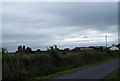
1

Auchenharvie Castle Farm
Ruined castle on the farm ground.
Image: © wfmillar
Taken: 6 Jul 2010
0.05 miles
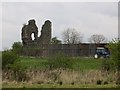
2
Ruins of Auchenharvie Castle
Ruined castle and Auchenharvie farm buildings pictured on a dull and windy 3rd August 2009 1.00pm
Image: © Gordon Dowie
Taken: 3 Aug 2009
0.05 miles
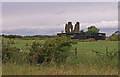
3
Auchenharvie Castle
15th century castle next to a 20th century slurry tank. This is Ayrshire, very much dairy farming country.
Image: © Richard Webb
Taken: 25 Apr 2014
0.09 miles
4
Auchenharvie Castle
Ruined castle behind Auchenharvie Farm.
Image: © wfmillar
Taken: 6 Jul 2010
0.09 miles
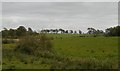
5
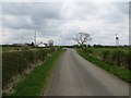
Road, Auchenharvie
Passing the farm and castle ruins.
Image: © Richard Webb
Taken: 25 Apr 2014
0.13 miles
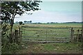
7
Watercourse, Auchenharvie
Wet pasture north of Auchenharvie.
Image: © Richard Webb
Taken: 25 Sep 2015
0.19 miles