IMAGES TAKEN NEAR TO
KILWINNING, KA13 7QP
Introduction
This page details the photographs taken nearby to KA13 7QP by members of the Geograph project.
The Geograph project started in 2005 with the aim of publishing, organising and preserving representative images for every square kilometre of Great Britain, Ireland and the Isle of Man.

There are currently over 7.5m images from over14,400 individuals and you can help contribute to the project by visiting https://www.geograph.org.uk
Image Map
Images are licensed for reuse under creativecommons.org/licenses/by-sa/2.0
Notes
- Clicking on the map will re-center to the selected point.
- The higher the marker number, the further away the image location is from the centre of the postcode.
Image Listing (4 Images Found)
Images are licensed for reuse under creativecommons.org/licenses/by-sa/2.0
Image
Details
Distance
2
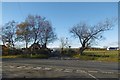
Crossroads, A778
Near Monkredding Quarry.
Image: © Richard Webb
Taken: 6 Nov 2016
0.14 miles
3
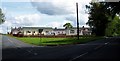
Holiday Chalets Monkreddan
Pictured at road junction on B778 Kilwinning to Auchentiber Road. Unsure if they are for permanent residents or Holiday homes. The site previously had static caravans but these were cleared a few years ago. 25th July 2009 12.10p.m.
Image: © Gordon Dowie
Taken: 25 Jul 2009
0.16 miles
4
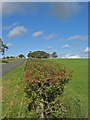
Hawthorn Hedge
Looking towards the small plantation at the minor road to Benthead Farm.
Image: © wfmillar
Taken: 9 Sep 2009
0.21 miles