IMAGES TAKEN NEAR TO
Benslie Row, KILWINNING, KA13 7QG
Introduction
This page details the photographs taken nearby to Benslie Row, KA13 7QG by members of the Geograph project.
The Geograph project started in 2005 with the aim of publishing, organising and preserving representative images for every square kilometre of Great Britain, Ireland and the Isle of Man.

There are currently over 7.5m images from over14,400 individuals and you can help contribute to the project by visiting https://www.geograph.org.uk
Image Map
Images are licensed for reuse under creativecommons.org/licenses/by-sa/2.0
Notes
- Clicking on the map will re-center to the selected point.
- The higher the marker number, the further away the image location is from the centre of the postcode.
Image Listing (10 Images Found)
Images are licensed for reuse under creativecommons.org/licenses/by-sa/2.0
Image
Details
Distance

5
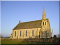
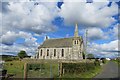
Church
Church with spire in winter sunshine.
Image: © Chris Court
Taken: 8 Jan 2006
0.09 miles
8
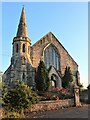
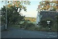
Church Manor
A church conversion in Montgreenan.
Image: © Alan Reid
Taken: 14 Jul 2021
0.11 miles
9
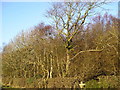
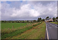
Benslie Wood
Benslie Wood photographed from the B785.
Image: © Chris Court
Taken: 8 Jan 2006
0.22 miles
10
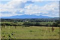
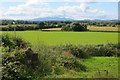
Arran view
Arran, beyond fields in Montgreenan.
Image: © Richard Webb
Taken: 1 Sep 2015
0.23 miles