IMAGES TAKEN NEAR TO
Eglinton, KILWINNING, KA13 7QD
Introduction
This page details the photographs taken nearby to KA13 7QD by members of the Geograph project.
The Geograph project started in 2005 with the aim of publishing, organising and preserving representative images for every square kilometre of Great Britain, Ireland and the Isle of Man.

There are currently over 7.5m images from over14,400 individuals and you can help contribute to the project by visiting https://www.geograph.org.uk
Image Map
Images are licensed for reuse under creativecommons.org/licenses/by-sa/2.0
Notes
- Clicking on the map will re-center to the selected point.
- The higher the marker number, the further away the image location is from the centre of the postcode.
Image Listing (218 Images Found)
Images are licensed for reuse under creativecommons.org/licenses/by-sa/2.0
Image
Details
Distance
1
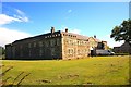
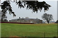
Knightsbridge House Eglington Park - Kilwinning
Image: © Ian Rainey
Taken: 18 May 2017
0.01 miles
2
Knightsbridge House, Eglinton Country Park
Image: © Billy McCrorie
Taken: 20 Nov 2016
0.02 miles
3
Knightsbridge House, Eglinton Country Park
Image: © Billy McCrorie
Taken: 20 Nov 2016
0.02 miles
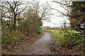
4
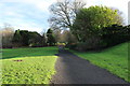
Path to Castle, Eglinton Country Park
Image: © Billy McCrorie
Taken: 4 Jan 2016
0.05 miles
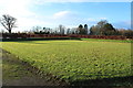
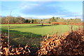
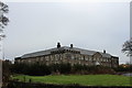
6
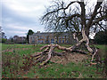
Eglinton Country Park
Abandoned food factory in the park. Hopefully some use will soon be found for this great building.
Image: © wfmillar
Taken: 20 Nov 2007
0.05 miles
7
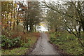
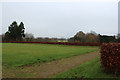
Woodland Path at Eglinton Country Park
Image: © Billy McCrorie
Taken: 20 Nov 2016
0.05 miles
8
Path to the Garden, Eglinton Country Park
Image: © Billy McCrorie
Taken: 20 Nov 2016
0.05 miles