IMAGES TAKEN NEAR TO
KILWINNING, KA13 7QA
Introduction
This page details the photographs taken nearby to KA13 7QA by members of the Geograph project.
The Geograph project started in 2005 with the aim of publishing, organising and preserving representative images for every square kilometre of Great Britain, Ireland and the Isle of Man.

There are currently over 7.5m images from over14,400 individuals and you can help contribute to the project by visiting https://www.geograph.org.uk
Image Map
Images are licensed for reuse under creativecommons.org/licenses/by-sa/2.0
Notes
- Clicking on the map will re-center to the selected point.
- The higher the marker number, the further away the image location is from the centre of the postcode.
Image Listing (19 Images Found)
Images are licensed for reuse under creativecommons.org/licenses/by-sa/2.0
Image
Details
Distance
2
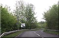
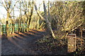
Path, Eglinton Country Park
Passing between Ladyha' Park and a wood.
Image: © Richard Webb
Taken: 1 Sep 2015
0.11 miles
3
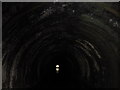
There's a hole through my park, Ladyha', Ladyha'
The Earls of Eglinton, like many other landowners, were keen to develop any mineral resources that could be found under their land and Eglinton Castle, between Kilwinning and Irvine, sat above several useful seams of coal and iron. One of the collieries sunk was hidden in a strip of woodland in Ladyha' Park, north-west of the castle, and to get the coal to his ironworks situated only a mile or so away, a short branch line was built, with a tunnel under a rise in the ground. This tunnel, approximately 150 yards long, still survives in what is today Eglinton Country Park, with padlocked gates on both ends. There are also ruins of the former colliery, which finally closed in the 1920s. This is the inside of the tunnel, looking towards the north portal, reflected in water that has collected on the floor.
Image: © A-M-Jervis
Taken: 19 Jan 2008
0.13 miles
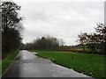
7

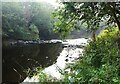
River Garnock
The Garnock just above the confluence with a major tributary, the Lugton Water.
Image: © Richard Webb
Taken: 13 Aug 2009
0.21 miles
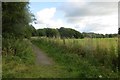
9
River Garnock, near to its tidal limit
The river rises on Hill of Stake, the highest point of the West Renfrew Heights to the north.
Image: © Alan Reid
Taken: 8 Sep 2023
0.22 miles