IMAGES TAKEN NEAR TO
Fergushill Road, KILWINNING, KA13 7LN
Introduction
This page details the photographs taken nearby to Fergushill Road, KA13 7LN by members of the Geograph project.
The Geograph project started in 2005 with the aim of publishing, organising and preserving representative images for every square kilometre of Great Britain, Ireland and the Isle of Man.

There are currently over 7.5m images from over14,400 individuals and you can help contribute to the project by visiting https://www.geograph.org.uk
Image Map
Images are licensed for reuse under creativecommons.org/licenses/by-sa/2.0
Notes
- Clicking on the map will re-center to the selected point.
- The higher the marker number, the further away the image location is from the centre of the postcode.
Image Listing (5 Images Found)
Images are licensed for reuse under creativecommons.org/licenses/by-sa/2.0
Image
Details
Distance
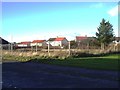
2
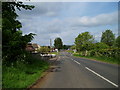
Fergushill Road
On the outskirts of Kilwinning.
Image: © Gordon Dowie
Taken: 25 May 2010
0.12 miles
3
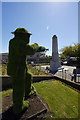
Kilwinning cemetery war memorial
The memorial and cemetery was photographed on May 18th 2017 as part of the spirit of Scotland remembrance project : http://the-remembrance-project.blogspot.co.uk/
209 photos here : https://flic.kr/s/aHskWJPEvV
Image: © david cameron photographer
Taken: 18 May 2017
0.24 miles
4
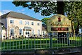
Buckreddan Care Home - Kilwinning
This was previously the Buckreddan Maternity Hospital a converted house to the south east of Kilwinning which may once have belonged to the owner of the Eglinton Iron Works, the hospital was originally opened as the Kilwinning Maternity Home by the local authority in September 1932.
Image: © Ian Rainey
Taken: 29 Apr 2019
0.24 miles
5
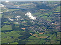
Kilwinning from the air
The large wood just left of lower centre, and above the curve of a disused railway, is Corsehillmuir Wood Nature Reserve [SWT]. The River Garnock is in the distance.
Image: © M J Richardson
Taken: 1 Oct 2016
0.25 miles