IMAGES TAKEN NEAR TO
KILWINNING, KA13 7JL
Introduction
This page details the photographs taken nearby to KA13 7JL by members of the Geograph project.
The Geograph project started in 2005 with the aim of publishing, organising and preserving representative images for every square kilometre of Great Britain, Ireland and the Isle of Man.

There are currently over 7.5m images from over14,400 individuals and you can help contribute to the project by visiting https://www.geograph.org.uk
Image Map
Images are licensed for reuse under creativecommons.org/licenses/by-sa/2.0
Notes
- Clicking on the map will re-center to the selected point.
- The higher the marker number, the further away the image location is from the centre of the postcode.
Image Listing (5 Images Found)
Images are licensed for reuse under creativecommons.org/licenses/by-sa/2.0
Image
Details
Distance
1
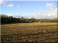
Stubble
Field of stubble, bordered to the west by woodland.
Image: © Chris Court
Taken: 14 Jan 2006
0.16 miles
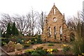
5
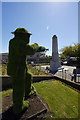
Kilwinning cemetery war memorial
The memorial and cemetery was photographed on May 18th 2017 as part of the spirit of Scotland remembrance project : http://the-remembrance-project.blogspot.co.uk/
209 photos here : https://flic.kr/s/aHskWJPEvV
Image: © david cameron photographer
Taken: 18 May 2017
0.25 miles