IMAGES TAKEN NEAR TO
Dalry Road, KILWINNING, KA13 7HH
Introduction
This page details the photographs taken nearby to Dalry Road, KA13 7HH by members of the Geograph project.
The Geograph project started in 2005 with the aim of publishing, organising and preserving representative images for every square kilometre of Great Britain, Ireland and the Isle of Man.

There are currently over 7.5m images from over14,400 individuals and you can help contribute to the project by visiting https://www.geograph.org.uk
Image Map
Images are licensed for reuse under creativecommons.org/licenses/by-sa/2.0
Notes
- Clicking on the map will re-center to the selected point.
- The higher the marker number, the further away the image location is from the centre of the postcode.
Image Listing (116 Images Found)
Images are licensed for reuse under creativecommons.org/licenses/by-sa/2.0
Image
Details
Distance
6
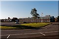
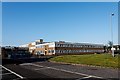
Bennett's Funeral Directors - Kilwinning
Also run buses/coaches
Image: © Ian Rainey
Taken: 25 Feb 2018
0.12 miles
7
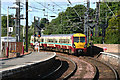
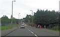
Kilwinning Station
Electric multiple unit 334021 arriving from Ardrossan to platform 2.
Image: © Peter Langsdale
Taken: 20 Jul 2008
0.16 miles
8
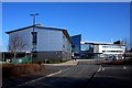
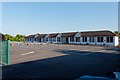
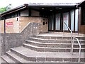
Ayrshire College - Kilwinning Campus
This view was taken from the car park so shows the rear left of the building with the main entrance in the middle of the photo.
Image: © Ian Rainey
Taken: 25 Feb 2018
0.16 miles
9
Bridge Church
Previously known as the Cornerstone Church
Image: © Ian Rainey
Taken: 2 Jun 2018
0.16 miles
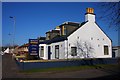
10
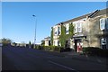
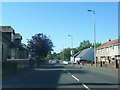
Taylors, Kilwinning
By the station on Byers Road.
Image: © Richard Webb
Taken: 6 Nov 2016
0.16 miles