IMAGES TAKEN NEAR TO
Dalry Road, KILWINNING, KA13 7HD
Introduction
This page details the photographs taken nearby to Dalry Road, KA13 7HD by members of the Geograph project.
The Geograph project started in 2005 with the aim of publishing, organising and preserving representative images for every square kilometre of Great Britain, Ireland and the Isle of Man.

There are currently over 7.5m images from over14,400 individuals and you can help contribute to the project by visiting https://www.geograph.org.uk
Image Map
Images are licensed for reuse under creativecommons.org/licenses/by-sa/2.0
Notes
- Clicking on the map will re-center to the selected point.
- The higher the marker number, the further away the image location is from the centre of the postcode.
Image Listing (186 Images Found)
Images are licensed for reuse under creativecommons.org/licenses/by-sa/2.0
Image
Details
Distance
1
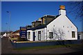
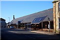
Bennett's Funeral Directors - Kilwinning
Also run buses/coaches
Image: © Ian Rainey
Taken: 25 Feb 2018
0.05 miles
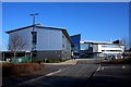
2
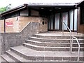
Bridge Church
Previously known as the Cornerstone Church
Image: © Ian Rainey
Taken: 2 Jun 2018
0.10 miles
4
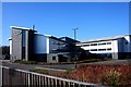
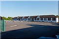
Ayrshire College - Kilwinning Campus
This view was taken from the car park so shows the rear left of the building with the main entrance in the middle of the photo.
Image: © Ian Rainey
Taken: 25 Feb 2018
0.10 miles
6
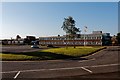
Caley House - Kilwinning
Built on the site of the old Caledonia Railway Station see
http://www.naheritagetrails.co.uk/heritagetrails_kilwinning_caleyhouse.php
Was originally the YMCA/YWCA but is now Flats
Image: © Ian Rainey
Taken: 25 Feb 2018
0.11 miles
7
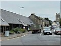
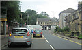
Kilwinning East railway station (site), Ayrshire
Opened in 1888 by the Lanarkshire & Ayrshire Railway (part of the Caledonian Railway) on its lines from Newton via Neilston to Ardrossan Harbour and Irvine, this station closed to passengers in 1932.
View east along Howgate to the site of the street building, which was to the left of the lorry. The railway ran under the street at this point. To the left, behind the street-level building and at a lower level were the platforms. The station was noted for an extremely tall signal box on the southbound platform. To the right, the lines split for Ardrossan and Irvine. The site has been completely redeveloped and no trace apparently remains.
Image: © Nigel Thompson
Taken: 11 Jul 2022
0.11 miles
8
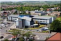
Ayrshire College - Kilwinning Campus
This was taken from the top of the clock tower
Image: © Ian Rainey
Taken: 25 May 2018
0.11 miles