IMAGES TAKEN NEAR TO
Sundrum Place, KILWINNING, KA13 6SY
Introduction
This page details the photographs taken nearby to Sundrum Place, KA13 6SY by members of the Geograph project.
The Geograph project started in 2005 with the aim of publishing, organising and preserving representative images for every square kilometre of Great Britain, Ireland and the Isle of Man.

There are currently over 7.5m images from over14,400 individuals and you can help contribute to the project by visiting https://www.geograph.org.uk
Image Map
Images are licensed for reuse under creativecommons.org/licenses/by-sa/2.0
Notes
- Clicking on the map will re-center to the selected point.
- The higher the marker number, the further away the image location is from the centre of the postcode.
Image Listing (10 Images Found)
Images are licensed for reuse under creativecommons.org/licenses/by-sa/2.0
Image
Details
Distance
1
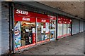
Pennyburn Newsagents & Post Office - Kilwinning
Image: © Ian Rainey
Taken: 31 May 2018
0.06 miles
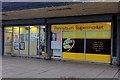
4
Pryde - Kilwinning
Pennyburn Regeneration Youth Development Enterprise
Image: © Ian Rainey
Taken: 31 May 2018
0.06 miles
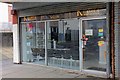
6
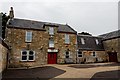
Cranberry Moss Community Centre Pennyburn - Kilwinning
Situated in the old Farm building
Image: © Ian Rainey
Taken: 31 May 2018
0.11 miles
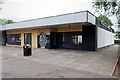
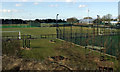
7
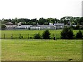
Kilwinning Sports Club
Viewed from an Ayr bound train.
Image: © Thomas Nugent
Taken: 9 Apr 2013
0.22 miles
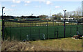
8
Kilwinning Sports Club
Viewed from an Ayr bound train.
Image: © Thomas Nugent
Taken: 9 Apr 2013
0.22 miles
9
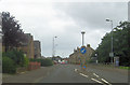
A738 at Segton Avenue junction Kilwinning
Image: © John Firth
Taken: 27 Jul 2012
0.23 miles
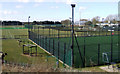
10
Kilwinning Sports Club
Viewed from an Ayr bound train.
Image: © Thomas Nugent
Taken: 9 Apr 2013
0.23 miles