IMAGES TAKEN NEAR TO
Ashgrove Road, KILWINNING, KA13 6PB
Introduction
This page details the photographs taken nearby to Ashgrove Road, KA13 6PB by members of the Geograph project.
The Geograph project started in 2005 with the aim of publishing, organising and preserving representative images for every square kilometre of Great Britain, Ireland and the Isle of Man.

There are currently over 7.5m images from over14,400 individuals and you can help contribute to the project by visiting https://www.geograph.org.uk
Image Map
Images are licensed for reuse under creativecommons.org/licenses/by-sa/2.0
Notes
- Clicking on the map will re-center to the selected point.
- The higher the marker number, the further away the image location is from the centre of the postcode.
Image Listing (49 Images Found)
Images are licensed for reuse under creativecommons.org/licenses/by-sa/2.0
Image
Details
Distance
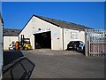
1
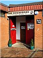
The Dogworks - Kilwinning
Dog training, grooming, daycare, shop
Image: © Ian Rainey
Taken: 30 May 2018
0.15 miles
3
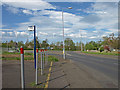
Whitehirst Park Road
Approaching the first roundabout.
Image: © wfmillar
Taken: 14 May 2009
0.15 miles
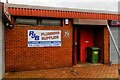
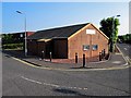
4
Mitie Property Services - Kilwinning
Pest and vermin control business
Image: © Ian Rainey
Taken: 28 Mar 2019
0.16 miles
5
Carney Contracts - Kilwinning
Groundworks and Civil Engineering Company
Image: © Ian Rainey
Taken: 30 May 2018
0.17 miles
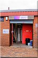
6
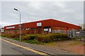
Ashgrove Workshops - Kilwinning
Small retail park beside the railway station
Image: © Ian Rainey
Taken: 28 Mar 2019
0.19 miles
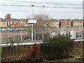
9
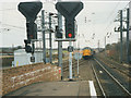
Kilwinning Junction
A southbound freight train at the junction just north of Kilwinning Station.
Image: © Stephen Craven
Taken: 9 Mar 1990
0.21 miles
10
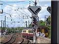
Kilwinning Junction
A Glasgow bound train leaves the Ayr/Stranraer line side of Kilwinning station under a web of catenary. The lines on the bottom left come from Largs and join the Ayr/Stranraer line here.
Image: © Thomas Nugent
Taken: 25 May 2006
0.21 miles