IMAGES TAKEN NEAR TO
Townhead, KILWINNING, KA13 6NT
Introduction
This page details the photographs taken nearby to Townhead, KA13 6NT by members of the Geograph project.
The Geograph project started in 2005 with the aim of publishing, organising and preserving representative images for every square kilometre of Great Britain, Ireland and the Isle of Man.

There are currently over 7.5m images from over14,400 individuals and you can help contribute to the project by visiting https://www.geograph.org.uk
Image Map
Images are licensed for reuse under creativecommons.org/licenses/by-sa/2.0
Notes
- Clicking on the map will re-center to the selected point.
- The higher the marker number, the further away the image location is from the centre of the postcode.
Image Listing (83 Images Found)
Images are licensed for reuse under creativecommons.org/licenses/by-sa/2.0
Image
Details
Distance
1
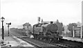
Kilwinning Station, with a Down freight going towards Ayr
View northward, towards Paisley and Glasgow; ex-Glasgow & South Western Glasgow St Enoch - Ayr - Stranraer main line, junction for Ardrossan. The Class H freight is headed by LMS-type Fairburn 4MT 2-6-4T No. 42190.
Image: © Ben Brooksbank
Taken: 17 Sep 1957
0.00 miles
3
Continuing work on interconnecting walkway at Kilwinning Station
See https://www.geograph.org.uk/photo/6121597 for earlier construction
Image: © Ian Rainey
Taken: 23 Jun 2019
0.01 miles
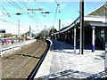
4
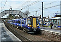
Kilwinning Station
This train was going from Largs to Glasgow Central.
Image: © Mary and Angus Hogg
Taken: 5 Apr 2013
0.01 miles
5
Kilwinning railway station
The Largs line. The Ayr line is behind the station building.
Image: © Thomas Nugent
Taken: 9 Apr 2013
0.01 miles
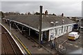
6
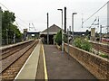
Kilwinning railway station, Ayrshire
Opened in 1840 by the Glasgow, Paisley, Kilmarnock & Ayr Railway (platforms on the left), this station is also the junction for the former Ardrossan Railway (platforms on the right), later extended to Largs. Both became part of the Glasgow & South Western Railway in the 1850s. The "Y" shaped platform building as well as the Ardrossan platforms to the right appear to have both been a later addition, as neither are shown on the 1857 OS map.
View south. The lines were electrified in 1986. The continuous footbridge with lifts was installed in 2019, replacing the two separate ones shown in Image
Image: © Nigel Thompson
Taken: 11 Jul 2022
0.01 miles
7
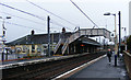
Kilwinning railway station
Platforms 3 & 4 are for services to Ayr and the south, Platforms 1 & 2 (beyond the station building) are for Largs, Ardrossan and the north.
Image: © Thomas Nugent
Taken: 5 Apr 2011
0.01 miles
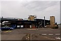
8
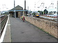
Kilwinning railway station, Ayrshire, 2009
Opened in 1840 by the Glasgow, Paisley, Kilmarnock & Ayr Railway (platforms on the left), this station is also the junction for the former Ardrossan Railway (platforms on the right), later extended to Largs. Both became part of the Glasgow & South Western Railway in the 1850s. The "Y" shaped platform building as well as the Ardrossan platforms to the right appear to have both been a later addition, as neither are shown on the 1857 OS map.
View south. The separate footbridges were replaced in 2019 - see Image for a 2022 view from the same camera position.
Image: © Nigel Thompson
Taken: 28 Aug 2009
0.01 miles
9
Kilwinning railway station
The Largs line is on the left, the footbridge over the Ayr line can just be seen behind the trees on the right.
Image: © Thomas Nugent
Taken: 9 Apr 2013
0.01 miles
10
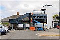
Pedestrian walkway connecting all the platforms under construction - Kilwinning
Image: © Ian Rainey
Taken: 22 May 2019
0.01 miles