IMAGES TAKEN NEAR TO
Newark, KILWINNING, KA13 6NA
Introduction
This page details the photographs taken nearby to Newark, KA13 6NA by members of the Geograph project.
The Geograph project started in 2005 with the aim of publishing, organising and preserving representative images for every square kilometre of Great Britain, Ireland and the Isle of Man.

There are currently over 7.5m images from over14,400 individuals and you can help contribute to the project by visiting https://www.geograph.org.uk
Image Map
Images are licensed for reuse under creativecommons.org/licenses/by-sa/2.0
Notes
- Clicking on the map will re-center to the selected point.
- The higher the marker number, the further away the image location is from the centre of the postcode.
Image Listing (9 Images Found)
Images are licensed for reuse under creativecommons.org/licenses/by-sa/2.0
Image
Details
Distance
1
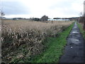
Looking towards West Byrehill Estate entrance
Image: © Brian Robertson
Taken: 8 Jan 2014
0.18 miles
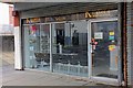
3

Pennyburn Newsagents & Post Office - Kilwinning
Image: © Ian Rainey
Taken: 31 May 2018
0.20 miles
4
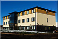
Montgomerie House - Kilwinning
North Ayrshire Council building since it was completed in 2006. It was sold in May 2018
Image: © Ian Rainey
Taken: 2 Feb 2019
0.21 miles

6
Pryde - Kilwinning
Pennyburn Regeneration Youth Development Enterprise
Image: © Ian Rainey
Taken: 31 May 2018
0.21 miles
7
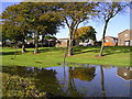
Reflections
Flooded area of landscaping bordering the A738, and adjacent to the housing estate. After several days' rain the flooding might be expected, but the dead young trees in the landscaping may be drowned if the ground is regularly waterlogged.
Image: © Chris Court
Taken: 13 Oct 2005
0.21 miles
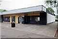
8
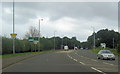
New junction outside St Lukes Primary school
A738 west
Image: © John Firth
Taken: 27 Jul 2012
0.22 miles
9
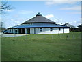
Mansfield Church
This modern circular Church replaced the old Mansfield Church nearer the town centre which was sold and is now a creche
Image: © Ian Rainey
Taken: 19 Apr 2006
0.23 miles