IMAGES TAKEN NEAR TO
Stobbs Crescent, KILWINNING, KA13 6JF
Introduction
This page details the photographs taken nearby to Stobbs Crescent, KA13 6JF by members of the Geograph project.
The Geograph project started in 2005 with the aim of publishing, organising and preserving representative images for every square kilometre of Great Britain, Ireland and the Isle of Man.

There are currently over 7.5m images from over14,400 individuals and you can help contribute to the project by visiting https://www.geograph.org.uk
Image Map
Images are licensed for reuse under creativecommons.org/licenses/by-sa/2.0
Notes
- Clicking on the map will re-center to the selected point.
- The higher the marker number, the further away the image location is from the centre of the postcode.
Image Listing (25 Images Found)
Images are licensed for reuse under creativecommons.org/licenses/by-sa/2.0
Image
Details
Distance
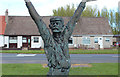
3
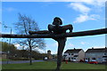
The "Ring" by David Annand, Kilwinning
Image: © Billy McCrorie
Taken: 2 May 2016
0.11 miles
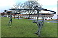
4
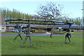
The "Ring" by David Annand, Kilwinning
Image: © Billy McCrorie
Taken: 2 May 2016
0.11 miles
5
The "Ring" by David Annand, Kilwinning
Image: © Billy McCrorie
Taken: 2 May 2016
0.11 miles
6
The "Ring" by David Annand, Kilwinning
Image: © Billy McCrorie
Taken: 2 May 2016
0.11 miles
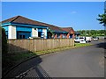
8
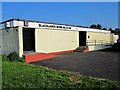
Blacklands Lawn Bowling Club - Kilwinning
Image: © Ian Rainey
Taken: 30 May 2018
0.13 miles
9
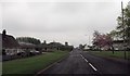
Nethermains Road looking south
From Shavian Terrace
Image: © John Firth
Taken: 19 May 2013
0.14 miles
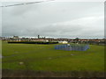
10
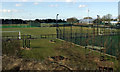
Kilwinning Sports Club
Viewed from an Ayr bound train.
Image: © Thomas Nugent
Taken: 9 Apr 2013
0.18 miles