IMAGES TAKEN NEAR TO
Howgate, KILWINNING, KA13 6EN
Introduction
This page details the photographs taken nearby to Howgate, KA13 6EN by members of the Geograph project.
The Geograph project started in 2005 with the aim of publishing, organising and preserving representative images for every square kilometre of Great Britain, Ireland and the Isle of Man.

There are currently over 7.5m images from over14,400 individuals and you can help contribute to the project by visiting https://www.geograph.org.uk
Image Map
Images are licensed for reuse under creativecommons.org/licenses/by-sa/2.0
Notes
- Clicking on the map will re-center to the selected point.
- The higher the marker number, the further away the image location is from the centre of the postcode.
Image Listing (213 Images Found)
Images are licensed for reuse under creativecommons.org/licenses/by-sa/2.0
Image
Details
Distance
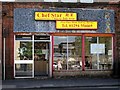
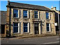
6
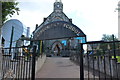
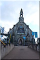
Rainbow Childcare
Situated in the old Mansfield Church
Image: © Ian Rainey
Taken: 2 Jun 2018
0.02 miles
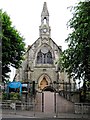
7
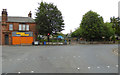
Old Kilwinning Housing Offices
Now replaced by new Offices at the opposite end of the town https://www.geograph.org.uk/photo/6039141
Image: © Ian Rainey
Taken: 10 Apr 2019
0.02 miles
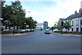
9
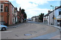
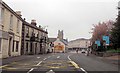
Almswall Road, Kilwinning
Approaching Howgate.
Image: © Billy McCrorie
Taken: 19 Aug 2014
0.03 miles
