IMAGES TAKEN NEAR TO
Almswall Road, KILWINNING, KA13 6BP
Introduction
This page details the photographs taken nearby to Almswall Road, KA13 6BP by members of the Geograph project.
The Geograph project started in 2005 with the aim of publishing, organising and preserving representative images for every square kilometre of Great Britain, Ireland and the Isle of Man.

There are currently over 7.5m images from over14,400 individuals and you can help contribute to the project by visiting https://www.geograph.org.uk
Image Map (Loading...)


Getting Data...Please wait
Leaflet Map data © OpenStreetMap
Images are licensed for reuse under creativecommons.org/licenses/by-sa/2.0
Notes
- Clicking on the map will re-center to the selected point.
- The higher the marker number, the further away the image location is from the centre of the postcode.
Image Listing (222 Images Found)
Images are licensed for reuse under creativecommons.org/licenses/by-sa/2.0
Image
Details
Distance
1
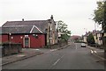
District 48 Orange Hall & Social Club, Kilwinning
Image: © Leslie Barrie
Taken: 9 Oct 2013
0.02 miles
6
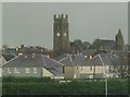
Kilwinning and the abbey
Viewed from a Glasgow bound train. The abbey ruin is to the right.
Image: © Thomas Nugent
Taken: 25 Nov 2009
0.08 miles