IMAGES TAKEN NEAR TO
Dunn Mews, KILMARNOCK, KA1 2RP
Introduction
This page details the photographs taken nearby to Dunn Mews, KA1 2RP by members of the Geograph project.
The Geograph project started in 2005 with the aim of publishing, organising and preserving representative images for every square kilometre of Great Britain, Ireland and the Isle of Man.

There are currently over 7.5m images from over14,400 individuals and you can help contribute to the project by visiting https://www.geograph.org.uk
Image Map
Images are licensed for reuse under creativecommons.org/licenses/by-sa/2.0
Notes
- Clicking on the map will re-center to the selected point.
- The higher the marker number, the further away the image location is from the centre of the postcode.
Image Listing (4 Images Found)
Images are licensed for reuse under creativecommons.org/licenses/by-sa/2.0
Image
Details
Distance
1
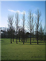
Park and Poplars
Shown on maps as a miniature golf course this seems to be now best described as a general park area.
Image: © Ian Rainey
Taken: 29 Mar 2006
0.04 miles
2
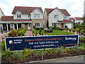
Showhomes for new development on Irvine Road, Kilmarnock
Image: © JThomas
Taken: 22 May 2021
0.18 miles
3
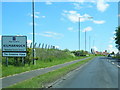
B7081 Irvine Road at Kilmarnock town boundary
Image: © Colin Pyle
Taken: 4 Jun 2013
0.24 miles
4
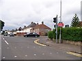
Irvine Road and Munro Avenue junction, Kilmarnock
Image: © Elliott Simpson
Taken: 6 Aug 2016
0.24 miles