IMAGES TAKEN NEAR TO
Sannox Road, KILMARNOCK, KA1 2PE
Introduction
This page details the photographs taken nearby to Sannox Road, KA1 2PE by members of the Geograph project.
The Geograph project started in 2005 with the aim of publishing, organising and preserving representative images for every square kilometre of Great Britain, Ireland and the Isle of Man.

There are currently over 7.5m images from over14,400 individuals and you can help contribute to the project by visiting https://www.geograph.org.uk
Image Map
Images are licensed for reuse under creativecommons.org/licenses/by-sa/2.0
Notes
- Clicking on the map will re-center to the selected point.
- The higher the marker number, the further away the image location is from the centre of the postcode.
Image Listing (15 Images Found)
Images are licensed for reuse under creativecommons.org/licenses/by-sa/2.0
Image
Details
Distance
1
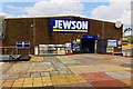
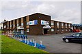
Jewson - Kilmarnock
The UK's leading chain of builders merchants. Supplier of building materials & equipment, supplies, tools & timber with over 600 branches across the UK
Image: © Ian Rainey
Taken: 25 Apr 2019
0.11 miles
2
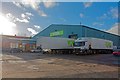
Yodel - Kilmarnock
Yodel is a delivery service company in the United Kingdom, and is one of the largest couriers along with Royal Mail. It was originally known as the Home Delivery Network, until it acquired the B2B and B2C operations of DHL Express UK and thereafter, re branded itself as Yodel in May 2010
Image: © Ian Rainey
Taken: 13 Nov 2018
0.11 miles
3
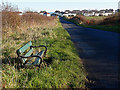
Bonnyton Road, Kilmarnock
Bench on this minor road between Kilmarnock and Knockintiber.
Image: © wfmillar
Taken: 7 Nov 2011
0.16 miles
4
Ayrshire Agencies - Kilmarnock
Double glazing, Conservatory Roofs and furniture, patio doors...
Image: © Ian Rainey
Taken: 9 May 2019
0.16 miles
5
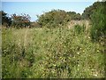
Glasgow, Paisley, Kilmarnock and Ayr Railway
The railway between Kilmarnock and Dalry, closed in 1966. My map, dated 2002 shows that this bit still had rails, but now it is overgrown, save for the cycle path to Irvine.
Image: © Richard Webb
Taken: 9 Sep 2009
0.18 miles
6
Munro Avenue, Kilmarnock
An early bypass. A Bellway sign on the right suggests that some former industrial land will be redeveloped for housing.
Image: © Richard Webb
Taken: 9 Sep 2009
0.21 miles
7
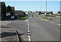
Junction on the B7064 at Bonnyton
Traffic-free on a wet Sunday morning.
Image: © Alan Reid
Taken: 6 Nov 2022
0.21 miles
8
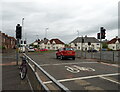
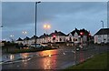
Traffic lights on Bonnyton Road
Junction with Munro Avenue (B7064).
Image: © JThomas
Taken: 20 May 2021
0.22 miles
9
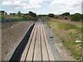
Passing Loop
Loop formed recently to allow engines on goods trains to change ends. This loop has been built on the route of the Kilmarnock to Crosshouse rail line which was closed and has been turned into a cycle route. The path continues in the distance from the access ramp on the left of picture.
Image: © Gordon Dowie
Taken: 12 Jul 2010
0.23 miles