IMAGES TAKEN NEAR TO
Ash Place, KILMARNOCK, KA1 2HJ
Introduction
This page details the photographs taken nearby to Ash Place, KA1 2HJ by members of the Geograph project.
The Geograph project started in 2005 with the aim of publishing, organising and preserving representative images for every square kilometre of Great Britain, Ireland and the Isle of Man.

There are currently over 7.5m images from over14,400 individuals and you can help contribute to the project by visiting https://www.geograph.org.uk
Image Map
Images are licensed for reuse under creativecommons.org/licenses/by-sa/2.0
Notes
- Clicking on the map will re-center to the selected point.
- The higher the marker number, the further away the image location is from the centre of the postcode.
Image Listing (7 Images Found)
Images are licensed for reuse under creativecommons.org/licenses/by-sa/2.0
Image
Details
Distance
1
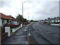
Dundonald Road (A759), Kilmarnock
Heading east.
Image: © JThomas
Taken: 21 May 2021
0.20 miles
4
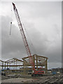
Grange School
New school under construction in Kilmarnock. The old Grange Academy can be seen in the background.
Image: © wfmillar
Taken: 20 Jan 2007
0.21 miles
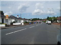
5
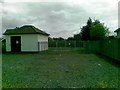
Electricity sub station, Dundonald Road, Grange
Image: © Alex McGregor
Taken: 16 May 2012
0.22 miles
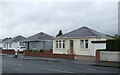
6
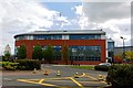
Grange Academy - Kilmarnock
Grange Academy is a non-denominational secondary school. The current school estate was constructed in 2007, with the new campus, Grange Campus, opening in 2008 which also houses Annanhill Primary School and Park School
Image: © Ian Rainey
Taken: 25 Apr 2019
0.24 miles
7

Park Hotel, Kilmarnock
Also providing banqueting and conference facilities, this hotel lies next to Rugby Park, the home of Kilmarnock Football Club.
Image: © Mary and Angus Hogg
Taken: 8 Jun 2013
0.24 miles