IMAGES TAKEN NEAR TO
East Woodstock Court, KILMARNOCK, KA1 2AS
Introduction
This page details the photographs taken nearby to East Woodstock Court, KA1 2AS by members of the Geograph project.
The Geograph project started in 2005 with the aim of publishing, organising and preserving representative images for every square kilometre of Great Britain, Ireland and the Isle of Man.

There are currently over 7.5m images from over14,400 individuals and you can help contribute to the project by visiting https://www.geograph.org.uk
Image Map
Images are licensed for reuse under creativecommons.org/licenses/by-sa/2.0
Notes
- Clicking on the map will re-center to the selected point.
- The higher the marker number, the further away the image location is from the centre of the postcode.
Image Listing (245 Images Found)
Images are licensed for reuse under creativecommons.org/licenses/by-sa/2.0
Image
Details
Distance
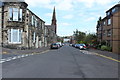
5
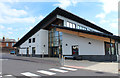
Sir Alexander Fleming Centre, Kilmarnock
Image: © Billy McCrorie
Taken: 15 Aug 2016
0.04 miles
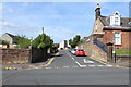
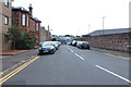
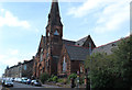
7
Old Kirk Woodstock Street, Kilmarnock
On the door it says Ayrshire Climbing and Activity Centre.
Image: © Billy McCrorie
Taken: 15 Aug 2016
0.06 miles
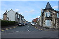
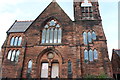
8
Old Kirk Woodstock Street, Kilmarnock
Notice on the door reads Ayrshire Climbing and Activity Centre.
Image: © Billy McCrorie
Taken: 15 Aug 2016
0.06 miles
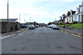
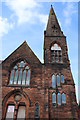
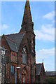
9
Old Kirk Woodstock Street, Kilmarnock
Image: © Billy McCrorie
Taken: 15 Aug 2016
0.06 miles
10
Old Kirk Woodstock Street, Kilmarnock
Notice on the door says it's a Climbing and Activity Centre.
Image: © Billy McCrorie
Taken: 15 Aug 2016
0.06 miles