IMAGES TAKEN NEAR TO
Nelson Street, KILMARNOCK, KA1 2AA
Introduction
This page details the photographs taken nearby to Nelson Street, KA1 2AA by members of the Geograph project.
The Geograph project started in 2005 with the aim of publishing, organising and preserving representative images for every square kilometre of Great Britain, Ireland and the Isle of Man.

There are currently over 7.5m images from over14,400 individuals and you can help contribute to the project by visiting https://www.geograph.org.uk
Image Map
Images are licensed for reuse under creativecommons.org/licenses/by-sa/2.0
Notes
- Clicking on the map will re-center to the selected point.
- The higher the marker number, the further away the image location is from the centre of the postcode.
Image Listing (350 Images Found)
Images are licensed for reuse under creativecommons.org/licenses/by-sa/2.0
Image
Details
Distance
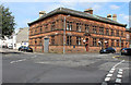
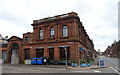
1

Former Kilmarnock Standard Printing Office
Category B-listed. Late 19th century. On the corner of Grange Place and Nelson Street.
Image: © Leslie Barrie
Taken: 31 May 2014
0.00 miles
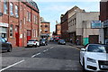
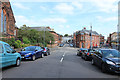
4
Junction of Grange Street & Grange Place
Image: © Billy McCrorie
Taken: 15 Aug 2016
0.02 miles
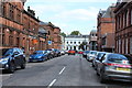
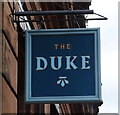
7
The Duke, Kilmarnock
On John Finnie Street.
Image: © JThomas
Taken: 22 May 2021
0.03 miles
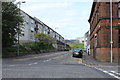
9
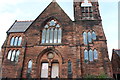
Old Kirk Woodstock Street, Kilmarnock
On the door it says Ayrshire Climbing and Activity Centre.
Image: © Billy McCrorie
Taken: 15 Aug 2016
0.04 miles
10
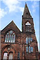
Old Kirk Woodstock Street, Kilmarnock
Notice on the door reads Ayrshire Climbing and Activity Centre.
Image: © Billy McCrorie
Taken: 15 Aug 2016
0.04 miles