IMAGES TAKEN NEAR TO
Castlepark Circle, IRVINE, KA12 9PR
Introduction
This page details the photographs taken nearby to Castlepark Circle, KA12 9PR by members of the Geograph project.
The Geograph project started in 2005 with the aim of publishing, organising and preserving representative images for every square kilometre of Great Britain, Ireland and the Isle of Man.

There are currently over 7.5m images from over14,400 individuals and you can help contribute to the project by visiting https://www.geograph.org.uk
Image Map
Images are licensed for reuse under creativecommons.org/licenses/by-sa/2.0
Notes
- Clicking on the map will re-center to the selected point.
- The higher the marker number, the further away the image location is from the centre of the postcode.
Image Listing (6 Images Found)
Images are licensed for reuse under creativecommons.org/licenses/by-sa/2.0
Image
Details
Distance
1
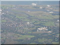
Irvine, the River Irvine and River Garnock
Viewed from the northeast. The R. Irvine is the loop to the left and the wider R. Garnock comes in from upper right; the area between them is the now disused racecourse. The Ayrshire Central Hospital is just below and to the right of centre - a large group of white buildings, and the A78 runs across the lower half of the picture.
Image: © M J Richardson
Taken: 1 Oct 2016
0.16 miles
2
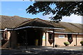
Douglas Grant Rehabilitation Centre, Irvine
Image: © Billy McCrorie
Taken: 16 Aug 2018
0.21 miles
3
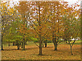
Autumn in the grounds of Irvine Central Hospital
Image: © wfmillar
Taken: 8 Nov 2010
0.22 miles
4
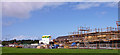
Castlepark, Irvine
New build in this large housing area of Irvine.
Image: © wfmillar
Taken: 14 Sep 2010
0.24 miles
5
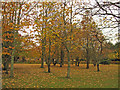
Autumn in the grounds of Irvine Central Hospital
The Douglas Grant Rehabilitation Centre can just be spotted through the trees.
Image: © wfmillar
Taken: 8 Nov 2010
0.24 miles
6
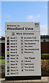
Welcome to Woodland View
At Ayrshire Central Hospital in Irvine.
Image: © Billy McCrorie
Taken: 8 Oct 2019
0.25 miles