IMAGES TAKEN NEAR TO
Leven Place, IRVINE, KA12 9PA
Introduction
This page details the photographs taken nearby to Leven Place, KA12 9PA by members of the Geograph project.
The Geograph project started in 2005 with the aim of publishing, organising and preserving representative images for every square kilometre of Great Britain, Ireland and the Isle of Man.

There are currently over 7.5m images from over14,400 individuals and you can help contribute to the project by visiting https://www.geograph.org.uk
Image Map
Images are licensed for reuse under creativecommons.org/licenses/by-sa/2.0
Notes
- Clicking on the map will re-center to the selected point.
- The higher the marker number, the further away the image location is from the centre of the postcode.
Image Listing (10 Images Found)
Images are licensed for reuse under creativecommons.org/licenses/by-sa/2.0
Image
Details
Distance
1
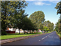
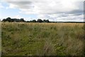
Castlepark, Irvine
Tree lined ring road adjacent to the A78 Bypass.
Image: © wfmillar
Taken: 14 Sep 2010
0.05 miles
2
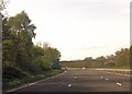
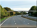
A78 approaching footbridge near The Circle
Image: © John Firth
Taken: 15 May 2014
0.17 miles
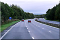
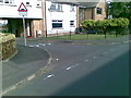
4
Footbridge from hospital over A78
Near The Circle
Image: © John Firth
Taken: 19 May 2013
0.20 miles
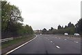
5
Land awaiting development, Irvine
Rough ground, unused for some time with house building nearby.
Image: © Richard Webb
Taken: 1 Sep 2015
0.21 miles
8
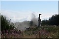
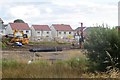
House building, Irvine
A drill has just been fired up on a new bit of ground.
Image: © Richard Webb
Taken: 1 Sep 2015
0.23 miles
9
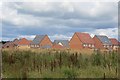
New houses, Irvine
A big chunk of land between the A736 and A78 is being developed for housing.
Image: © Richard Webb
Taken: 1 Sep 2015
0.24 miles
10
House building, Irvine
Looking into the active construction area from currently unused land.
Image: © Richard Webb
Taken: 1 Sep 2015
0.24 miles