IMAGES TAKEN NEAR TO
Dunvegan Place, IRVINE, KA12 9NA
Introduction
This page details the photographs taken nearby to Dunvegan Place, KA12 9NA by members of the Geograph project.
The Geograph project started in 2005 with the aim of publishing, organising and preserving representative images for every square kilometre of Great Britain, Ireland and the Isle of Man.

There are currently over 7.5m images from over14,400 individuals and you can help contribute to the project by visiting https://www.geograph.org.uk
Image Map
Images are licensed for reuse under creativecommons.org/licenses/by-sa/2.0
Notes
- Clicking on the map will re-center to the selected point.
- The higher the marker number, the further away the image location is from the centre of the postcode.
Image Listing (5 Images Found)
Images are licensed for reuse under creativecommons.org/licenses/by-sa/2.0
Image
Details
Distance
1
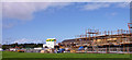
Castlepark, Irvine
New build in this large housing area of Irvine.
Image: © wfmillar
Taken: 14 Sep 2010
0.16 miles
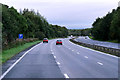
3
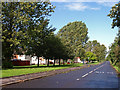
Castlepark, Irvine
Tree lined ring road adjacent to the A78 Bypass.
Image: © wfmillar
Taken: 14 Sep 2010
0.19 miles
4
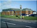
Castlepark Community Centre
The Castlepark Community Centre is active weekly with Community Groups from Parents & Toddlers, Dancing Schools, Sewing Groups, Computer Class, Boys Football, Gingerbread Group, Cookery Class, Karate Class. It has been active for over thirty years.
Image: © Ian Rainey
Taken: 29 Mar 2006
0.24 miles