IMAGES TAKEN NEAR TO
Bartonholm Gardens, IRVINE, KA12 8TD
Introduction
This page details the photographs taken nearby to Bartonholm Gardens, KA12 8TD by members of the Geograph project.
The Geograph project started in 2005 with the aim of publishing, organising and preserving representative images for every square kilometre of Great Britain, Ireland and the Isle of Man.

There are currently over 7.5m images from over14,400 individuals and you can help contribute to the project by visiting https://www.geograph.org.uk
Image Map
Images are licensed for reuse under creativecommons.org/licenses/by-sa/2.0
Notes
- Clicking on the map will re-center to the selected point.
- The higher the marker number, the further away the image location is from the centre of the postcode.
Image Listing (18 Images Found)
Images are licensed for reuse under creativecommons.org/licenses/by-sa/2.0
Image
Details
Distance
1
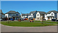
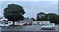
New Houses On Towns Moor
Recently developed housing area on the western edge of Irvine.
Image: © Mary and Angus Hogg
Taken: 12 May 2018
0.02 miles
2
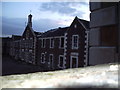
Ravenspark asylum
Some of what's left of Ravenspark
Image: © Scott
Taken: 31 May 2007
0.03 miles
3
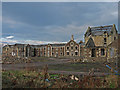
Ravenspark Asylum
Now in developers hands. 117 flats plus houses etc. The facades will be retained.
Image: © wfmillar
Taken: 20 Nov 2007
0.03 miles
4
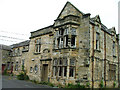
Ravenspark Hospital
The formidable but beautiful Governor's Admin Wing of the now abandoned Ravenspark Hospital in Irvine, formerly the Cunninghame Poorshouse. Cited as a "significant but not Listed" building in the Local Plan. Demolished early 2008 for housing development.
Image: © Unknown
Taken: Unknown
0.06 miles
5
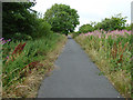
Cycle path at Irvine
Heading north near Ravenspark, the main railway line to Ayr is on the left.
Image: © Thomas Nugent
Taken: 6 Aug 2018
0.10 miles
6
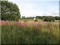
Links, Bogside
Rough land between two golf courses. (Irvine G.C. and Ravenspark G.C.)
Image: © Richard Webb
Taken: 13 Aug 2009
0.15 miles
7
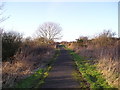
Cycle Track
Cycle track from Irvine to Stevenston, at this point also part of Irvine Town Trail.
Image: © Chris Court
Taken: 18 Feb 2006
0.15 miles
8
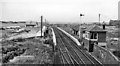
Bogside Racecourse Station
View NW, towards Glasgow; ex-GSW Glasgow - Ayr - Stranraer main line. The racecourse being disused, this station was closed 2/1/67.
Image: © Ben Brooksbank
Taken: 26 Sep 1961
0.18 miles
9
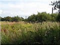
Links, Bogside
Rough land beside the Garnock estuary. Glasgow and South Western Railway, still in use and electrified can be seen beyond the vegetation. The Irvine Golf Club occupies the links beyond the railway.
Image: © Richard Webb
Taken: 13 Aug 2009
0.19 miles