IMAGES TAKEN NEAR TO
Williamfield Park, IRVINE, KA12 8SG
Introduction
This page details the photographs taken nearby to Williamfield Park, KA12 8SG by members of the Geograph project.
The Geograph project started in 2005 with the aim of publishing, organising and preserving representative images for every square kilometre of Great Britain, Ireland and the Isle of Man.

There are currently over 7.5m images from over14,400 individuals and you can help contribute to the project by visiting https://www.geograph.org.uk
Image Map
Images are licensed for reuse under creativecommons.org/licenses/by-sa/2.0
Notes
- Clicking on the map will re-center to the selected point.
- The higher the marker number, the further away the image location is from the centre of the postcode.
Image Listing (51 Images Found)
Images are licensed for reuse under creativecommons.org/licenses/by-sa/2.0
Image
Details
Distance
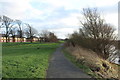
4
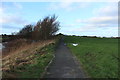
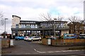
Riverside Footpath, Irvine
Also cycle route 7.
Image: © Billy McCrorie
Taken: 27 Dec 2016
0.12 miles

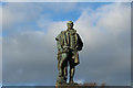
9
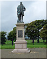
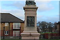
Burns Statue, Irvine
Locked away behind a high secure fence on Towns Moor. Category B Listed http://portal.historicenvironment.scot/designation/LB35418 .
Image: © Thomas Nugent
Taken: 6 Aug 2018
0.14 miles