IMAGES TAKEN NEAR TO
Waterside, IRVINE, KA12 8QJ
Introduction
This page details the photographs taken nearby to Waterside, KA12 8QJ by members of the Geograph project.
The Geograph project started in 2005 with the aim of publishing, organising and preserving representative images for every square kilometre of Great Britain, Ireland and the Isle of Man.

There are currently over 7.5m images from over14,400 individuals and you can help contribute to the project by visiting https://www.geograph.org.uk
Image Map
Images are licensed for reuse under creativecommons.org/licenses/by-sa/2.0
Notes
- Clicking on the map will re-center to the selected point.
- The higher the marker number, the further away the image location is from the centre of the postcode.
Image Listing (199 Images Found)
Images are licensed for reuse under creativecommons.org/licenses/by-sa/2.0
Image
Details
Distance
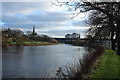
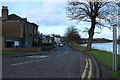
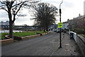
5
Waterside, Irvine, North Ayrshire
An area of the town particularly susceptible to flooding.
Image: © Mark S
Taken: 20 Jul 2019
0.04 miles
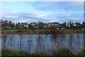
6
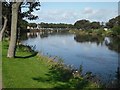
River Irvine
Downstream view from near the Marress roundabout.
Image: © Richard Webb
Taken: 9 Sep 2009
0.05 miles
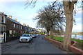
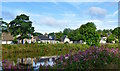
9
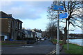
Waterside, Irvine
Also cycle route 73.
Image: © Billy McCrorie
Taken: 27 Dec 2016
0.05 miles