IMAGES TAKEN NEAR TO
Maress Road, IRVINE, KA12 8PE
Introduction
This page details the photographs taken nearby to Maress Road, KA12 8PE by members of the Geograph project.
The Geograph project started in 2005 with the aim of publishing, organising and preserving representative images for every square kilometre of Great Britain, Ireland and the Isle of Man.

There are currently over 7.5m images from over14,400 individuals and you can help contribute to the project by visiting https://www.geograph.org.uk
Image Map
Images are licensed for reuse under creativecommons.org/licenses/by-sa/2.0
Notes
- Clicking on the map will re-center to the selected point.
- The higher the marker number, the further away the image location is from the centre of the postcode.
Image Listing (128 Images Found)
Images are licensed for reuse under creativecommons.org/licenses/by-sa/2.0
Image
Details
Distance
1
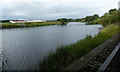
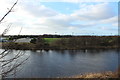
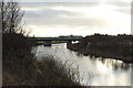
The River Irvine
Looking downstream from under the Marress Road bridge.
Image: © Thomas Nugent
Taken: 6 Aug 2018
0.03 miles
2
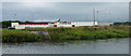
Irvine Sports Club
Sports fields and clubhouse contained within a loop of the River Irvine.
Image: © Thomas Nugent
Taken: 6 Aug 2018
0.03 miles
4
The River Irvine
Looking downstream from under the Marress Road bridge.
Image: © Thomas Nugent
Taken: 6 Aug 2018
0.06 miles
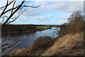
5
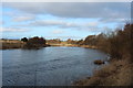
River Irvine
Looking over to the Irvine Sports Club.
Image: © Billy McCrorie
Taken: 27 Dec 2016
0.06 miles
6
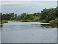
River Irvine
Building on the right is the Irvine Sports Club.
Image: © Billy McCrorie
Taken: 27 Dec 2016
0.07 miles
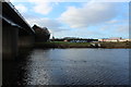
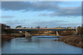
8
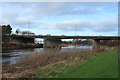
Road Bridge, Irvine
Carrying the A737(Marress Road).
Image: © Billy McCrorie
Taken: 27 Dec 2016
0.08 miles
10
Road Bridge, Irvine
Carrying the A737(Marress Road).
Image: © Billy McCrorie
Taken: 27 Dec 2016
0.08 miles