IMAGES TAKEN NEAR TO
Thornhouse Avenue, IRVINE, KA12 0LT
Introduction
This page details the photographs taken nearby to Thornhouse Avenue, KA12 0LT by members of the Geograph project.
The Geograph project started in 2005 with the aim of publishing, organising and preserving representative images for every square kilometre of Great Britain, Ireland and the Isle of Man.

There are currently over 7.5m images from over14,400 individuals and you can help contribute to the project by visiting https://www.geograph.org.uk
Image Map
Images are licensed for reuse under creativecommons.org/licenses/by-sa/2.0
Notes
- Clicking on the map will re-center to the selected point.
- The higher the marker number, the further away the image location is from the centre of the postcode.
Image Listing (5 Images Found)
Images are licensed for reuse under creativecommons.org/licenses/by-sa/2.0
Image
Details
Distance
1
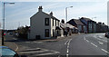
Road junction
Junction of Mill Road with Annick Road in Irvine.
Image: © Gordon Dowie
Taken: 12 Apr 2010
0.20 miles
2
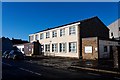
NHS Ballot Road Clinic - Irvine
Healthcare clinic part of the NHS
Image: © Ian Rainey
Taken: 8 Nov 2018
0.23 miles
3
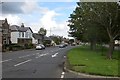
Bank Street, Irvine
The A736 in a residential area of Irvine.
Image: © Richard Webb
Taken: 1 Sep 2015
0.23 miles
4
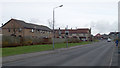
Speed sign
Speed indication sign on Woodlands Avenue Irvine. 7th April 2010 11.55am.
Image: © Gordon Dowie
Taken: 7 Apr 2010
0.24 miles
5
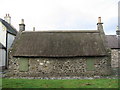
The Heckling Shop
Robert Burns worked here.
Image: © wfmillar
Taken: 4 Oct 2006
0.24 miles