IMAGES TAKEN NEAR TO
Scott Crescent, KILMARNOCK, KA1 1SH
Introduction
This page details the photographs taken nearby to Scott Crescent, KA1 1SH by members of the Geograph project.
The Geograph project started in 2005 with the aim of publishing, organising and preserving representative images for every square kilometre of Great Britain, Ireland and the Isle of Man.

There are currently over 7.5m images from over14,400 individuals and you can help contribute to the project by visiting https://www.geograph.org.uk
Image Map
Images are licensed for reuse under creativecommons.org/licenses/by-sa/2.0
Notes
- Clicking on the map will re-center to the selected point.
- The higher the marker number, the further away the image location is from the centre of the postcode.
Image Listing (41 Images Found)
Images are licensed for reuse under creativecommons.org/licenses/by-sa/2.0
Image
Details
Distance
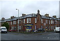
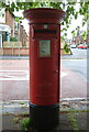
2
McLelland Drive, Kilmarnock
Traditional red sandstone properties in this residential part of the town.
Image: © Mary and Angus Hogg
Taken: 8 Jun 2013
0.08 miles
3
Barbadoes Drive, Kilmarnock
Showing position of Postbox No. KA1 23.
See Image] for postbox.
Image: © JThomas
Taken: 21 May 2021
0.12 miles
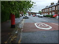
5
Elizabethan postbox on McLelland Drive, Kilmarnock
Postbox No. KA1 23.
See Image] for contex.
Image: © JThomas
Taken: 21 May 2021
0.13 miles
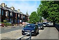
6
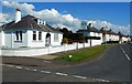
Blackwood Avenue, Kilmarnock
Well maintained residential properties on the west side of Kilmarnock.
Image: © Mary and Angus Hogg
Taken: 8 Jun 2013
0.14 miles
7
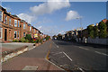
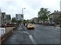
Dundonald Road
Looking towards the town centre.
Image: © Thomas Nugent
Taken: 27 Oct 2010
0.15 miles
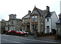
8
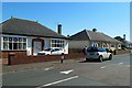
Holmes Road, Kilmarnock
Well maintained bungalows on the west side of Kilmarnock.
Image: © Mary and Angus Hogg
Taken: 8 Jun 2013
0.15 miles
9
Dundonald Road (A759), Kilmarnock
Heading towards the town centre.
Image: © JThomas
Taken: 21 May 2021
0.15 miles
10
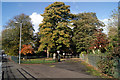
Howard Park gates
At McLelland Drive, at the junction with Fairyhill Road.
Image: © Thomas Nugent
Taken: 27 Oct 2010
0.17 miles