IMAGES TAKEN NEAR TO
Wallace Street, KILMARNOCK, KA1 1SB
Introduction
This page details the photographs taken nearby to Wallace Street, KA1 1SB by members of the Geograph project.
The Geograph project started in 2005 with the aim of publishing, organising and preserving representative images for every square kilometre of Great Britain, Ireland and the Isle of Man.

There are currently over 7.5m images from over14,400 individuals and you can help contribute to the project by visiting https://www.geograph.org.uk
Image Map (Loading...)


Getting Data...Please wait
Leaflet Map data © OpenStreetMap
Images are licensed for reuse under creativecommons.org/licenses/by-sa/2.0
Notes
- Clicking on the map will re-center to the selected point.
- The higher the marker number, the further away the image location is from the centre of the postcode.
Image Listing (56 Images Found)
Images are licensed for reuse under creativecommons.org/licenses/by-sa/2.0
Image
Details
Distance
1

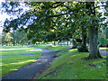
Howard Park
Looking out of the park, towards Wallace Street.
Image: © Thomas Nugent
Taken: 27 Oct 2010
0.07 miles
2

Alexander Marshall MD memorial
In a corner of Howard Park. The inscription reads as follows...
Alexander Marshall MD
Born 17th February 1827
Died 16th April 1894
For forty two years in practice in Kilmarnock
A skilled physician, generous, devoted to duty
Image: © Thomas Nugent
Taken: 27 Oct 2010
0.08 miles
4
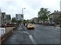
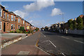
Dundonald Road (A759), Kilmarnock
Heading towards the town centre.
Image: © JThomas
Taken: 21 May 2021
0.09 miles
6
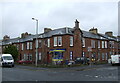
South Hamilton Street
At Dundonald Road, overshadowed by Rugby park stadium.
Image: © Thomas Nugent
Taken: 27 Oct 2010
0.11 miles
7
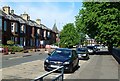
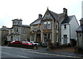
McLelland Drive, Kilmarnock
Traditional red sandstone properties in this residential part of the town.
Image: © Mary and Angus Hogg
Taken: 8 Jun 2013
0.11 miles
8
The Lady's Walk, Howard Park, Kilmarnock
The Lady's Walk lies in the former grounds of Kilmarnock House, and information on the House, its owners and some images may be seen at http://www.kilmarnock.com/dean.html. This photo shows The Lady's Walk to the right of the trees, and the original route of Kilmarnock Water is at the bottom of the bank, in the centre of the shot.
Image: © Alan Brown
Taken: 1 Oct 2005
0.12 miles
9
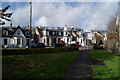
Dundonald Road
Looking towards the town centre.
Image: © Thomas Nugent
Taken: 27 Oct 2010
0.12 miles
10
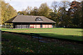
Bowling club in Howard Park
Closed for the season.
Image: © Thomas Nugent
Taken: 27 Oct 2010
0.14 miles