IMAGES TAKEN NEAR TO
Holmes Park Wynd, KILMARNOCK, KA1 1RS
Introduction
This page details the photographs taken nearby to Holmes Park Wynd, KA1 1RS by members of the Geograph project.
The Geograph project started in 2005 with the aim of publishing, organising and preserving representative images for every square kilometre of Great Britain, Ireland and the Isle of Man.

There are currently over 7.5m images from over14,400 individuals and you can help contribute to the project by visiting https://www.geograph.org.uk
Image Map
Images are licensed for reuse under creativecommons.org/licenses/by-sa/2.0
Notes
- Clicking on the map will re-center to the selected point.
- The higher the marker number, the further away the image location is from the centre of the postcode.
Image Listing (14 Images Found)
Images are licensed for reuse under creativecommons.org/licenses/by-sa/2.0
Image
Details
Distance
1
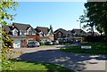
Holmes Park Gardens, Kilmarnock
New residential properties on the west side of Kilmarnock.
Image: © Mary and Angus Hogg
Taken: 8 Jun 2013
0.02 miles
2
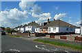
Woodside Avenue, Kilmarnock
Well maintained residential properties on the west side of Kilmarnock.
Image: © Mary and Angus Hogg
Taken: 8 Jun 2013
0.06 miles
3
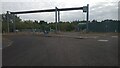
North Lodge Pumping Station
Having trawled the internet for a good while in order to try and find out exactly what the purpose of this modern-looking facility was, I eventually stumbled across a very technical case study of it, contained within a very technical report from New Zealand, and was quite overwhelmed. Who knew that the pumping of water was such a tricky business? A lot of attention was paid to various flow rates and the location of air valves.
It turns out it is a wastewater pumping station, built to prevent sewage entering the River Irvine during storm conditions, which seems to have been a longstanding problem. Whereas previously, if the pipe network was struggling with the volume of wastewater, valves would just open and divert it into the river via Combined Sewer Overflows (CSOs), now it gets directed through here and is then pumped to a treatment facility a few miles away. On top of that, if it is exceptionally wet there is a facility to divert up to 10,000 cubic metres into an underground holding tank that sits in between actual North Lodge and the pumping station and occupies a large proportion of the field that separates the two. The crane runners are there to allow easy removal of the big pumps (which, in combination, can deal with 900 litres per second) for maintenance.
Image: © Ian Dodds
Taken: 19 Sep 2022
0.11 miles
5

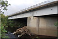
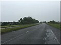
A71 River crossing
Under the bridge that takes the A71 over the River Irvine.
Image: © Scott
Taken: 4 Sep 2012
0.12 miles