IMAGES TAKEN NEAR TO
Hillier Road, KILMARNOCK, KA1 1AE
Introduction
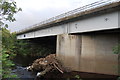
This page details the photographs taken nearby to Hillier Road, KA1 1AE by members of the Geograph project.
The Geograph project started in 2005 with the aim of publishing, organising and preserving representative images for every square kilometre of Great Britain, Ireland and the Isle of Man.

There are currently over 7.5m images from over14,400 individuals and you can help contribute to the project by visiting https://www.geograph.org.uk
Image Map
Images are licensed for reuse under creativecommons.org/licenses/by-sa/2.0
Notes
- Clicking on the map will re-center to the selected point.
- The higher the marker number, the further away the image location is from the centre of the postcode.
Image Listing (16 Images Found)
Images are licensed for reuse under creativecommons.org/licenses/by-sa/2.0
Image
Details
Distance
1
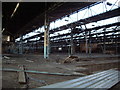
BMK factory
This is inside the main factory building,closed and earmarked for new housing
Image: © Scott
Taken: 31 May 2007
0.08 miles
2
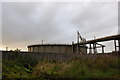
Gas Holder
Gas Holder and pipework, behind concrete flood defence wall.
Image: © Scott
Taken: 4 Sep 2012
0.11 miles
3
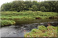
River meetings
Kilmarnock Water meets the River Irvine.
Image: © Scott
Taken: 4 Sep 2012
0.15 miles
4
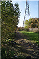
Footpath by Kilmarnock Water
Looking south from the footbridge at Fairyhill Road
Image: © Thomas Nugent
Taken: 27 Oct 2010
0.19 miles
5
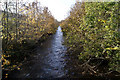
Kilmarnock Water
Looking downstream from the footbridge at Holmquarry Road at Burnside Street.
Image: © Thomas Nugent
Taken: 27 Oct 2010
0.19 miles
6
Flood defences at Kilmarnock water
No nonsense barrier by Burnside Street.
Image: © Thomas Nugent
Taken: 27 Oct 2010
0.19 miles
8
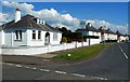
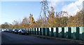
Blackwood Avenue, Kilmarnock
Well maintained residential properties on the west side of Kilmarnock.
Image: © Mary and Angus Hogg
Taken: 8 Jun 2013
0.20 miles