IMAGES TAKEN NEAR TO
Main Street, IRVINE, KA11 5BY
Introduction
This page details the photographs taken nearby to Main Street, KA11 5BY by members of the Geograph project.
The Geograph project started in 2005 with the aim of publishing, organising and preserving representative images for every square kilometre of Great Britain, Ireland and the Isle of Man.

There are currently over 7.5m images from over14,400 individuals and you can help contribute to the project by visiting https://www.geograph.org.uk
Image Map
Images are licensed for reuse under creativecommons.org/licenses/by-sa/2.0
Notes
- Clicking on the map will re-center to the selected point.
- The higher the marker number, the further away the image location is from the centre of the postcode.
Image Listing (29 Images Found)
Images are licensed for reuse under creativecommons.org/licenses/by-sa/2.0
Image
Details
Distance
1
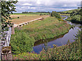
River Irvine and Pipeline, Drybridge
I think this is a sewage line.
Image: © wfmillar
Taken: 17 Aug 2010
0.04 miles
2
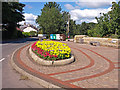
Flowerbed, Drybridge
Beside the B730 a nicely mono blocked sitting area in Drybridge.
Image: © wfmillar
Taken: 17 Aug 2010
0.04 miles
3
Flowerbed, Drybridge
Junction of Shewalton Road and Dreghorn Road.
Image: © wfmillar
Taken: 17 Aug 2010
0.05 miles
5
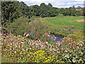
River Irvine, Drybridge
Himalayan Balsam well established here.
Image: © wfmillar
Taken: 17 Aug 2010
0.05 miles
6
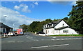
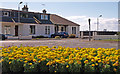
Shewalton Road, Drybridge
Modern housing at the junction of Shewalton Road and Dreghorn Road.
Image: © Mary and Angus Hogg
Taken: 31 Aug 2020
0.05 miles
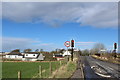
7

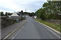
Road Bridge, Drybridge
B730 narrows to one lane crossing the Kilmarnock/Barassie line.
Image: © wfmillar
Taken: 17 Aug 2010
0.05 miles
9
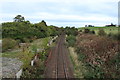
Railway Line at Drybridge
Going towards Kilmarnock.
Image: © Billy McCrorie
Taken: 12 Oct 2013
0.06 miles
10
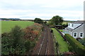
Railway Line at Drybridge
Going towards Troon.
Image: © Billy McCrorie
Taken: 12 Oct 2013
0.07 miles