IMAGES TAKEN NEAR TO
Ayr Road, IRVINE, KA11 5BF
Introduction
This page details the photographs taken nearby to Ayr Road, KA11 5BF by members of the Geograph project.
The Geograph project started in 2005 with the aim of publishing, organising and preserving representative images for every square kilometre of Great Britain, Ireland and the Isle of Man.

There are currently over 7.5m images from over14,400 individuals and you can help contribute to the project by visiting https://www.geograph.org.uk
Image Map
Images are licensed for reuse under creativecommons.org/licenses/by-sa/2.0
Notes
- Clicking on the map will re-center to the selected point.
- The higher the marker number, the further away the image location is from the centre of the postcode.
Image Listing (13 Images Found)
Images are licensed for reuse under creativecommons.org/licenses/by-sa/2.0
Image
Details
Distance
1
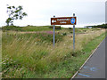
Dundonald Links Golf Club
The Club House in the distance.
Image: © Gordon Brown
Taken: 18 Dec 2021
0.05 miles
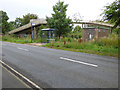
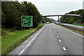
2

Auchengate
At the bus shelters at the Meadowhead Avenue footbridge.
Image: © Thomas Nugent
Taken: 6 Aug 2018
0.20 miles
3
Auchengate
A bus shelter at the footbridge to Meadowhead Avenue.
Image: © Thomas Nugent
Taken: 6 Aug 2018
0.20 miles
4
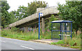
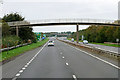
Bus shelter on Auchengate
At the footbridge which crosses the A78 dual carriageway to Meadowhead Avenue.
Image: © Thomas Nugent
Taken: 6 Aug 2018
0.20 miles
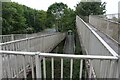
6
Northbound A78, Footbridge at Meadowhead Industrial Estate
Image: © David Dixon
Taken: 25 Sep 2019
0.21 miles
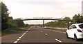
8
Footbridge over the A78 near Meadowhead Industrial Estate
Image: © David Dixon
Taken: 25 Sep 2019
0.22 miles
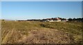
9
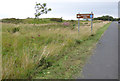
Auchengate
Near the road to Dundonald Links Golf Club.
Image: © Thomas Nugent
Taken: 6 Aug 2018
0.23 miles