IMAGES TAKEN NEAR TO
Gailes Court, KA11 4FR
Introduction
This page details the photographs taken nearby to Gailes Court, KA11 4FR by members of the Geograph project.
The Geograph project started in 2005 with the aim of publishing, organising and preserving representative images for every square kilometre of Great Britain, Ireland and the Isle of Man.

There are currently over 7.5m images from over14,400 individuals and you can help contribute to the project by visiting https://www.geograph.org.uk
Image Map
Images are licensed for reuse under creativecommons.org/licenses/by-sa/2.0
Notes
- Clicking on the map will re-center to the selected point.
- The higher the marker number, the further away the image location is from the centre of the postcode.
Image Listing (11 Images Found)
Images are licensed for reuse under creativecommons.org/licenses/by-sa/2.0
Image
Details
Distance
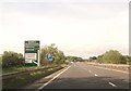
2
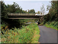
Slip road from the A78 to the A71 at Warrix Interchange
Image: © Colin Pyle
Taken: 4 Jun 2013
0.17 miles
3
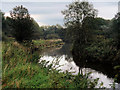
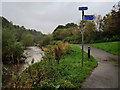
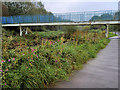
Footbridge, Annick Water
The riverside path is used by National Cycle Network route 73.
Image: © Richard Webb
Taken: 9 Sep 2009
0.19 miles
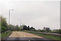
4
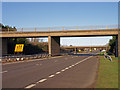
A78, Irvine By-pass
These two flyovers form a roundabout route above the bypass.
Image: © wfmillar
Taken: 30 Nov 2009
0.19 miles
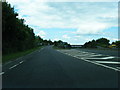
8
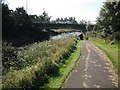
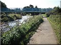
A71 crossing the Annick Water
National Cycle Network route 73 about to pass under the A71.
Image: © Richard Webb
Taken: 9 Sep 2009
0.21 miles