IMAGES TAKEN NEAR TO
Alexander Macmillan Way, IRVINE, KA11 4DS
Introduction
This page details the photographs taken nearby to Alexander Macmillan Way, KA11 4DS by members of the Geograph project.
The Geograph project started in 2005 with the aim of publishing, organising and preserving representative images for every square kilometre of Great Britain, Ireland and the Isle of Man.

There are currently over 7.5m images from over14,400 individuals and you can help contribute to the project by visiting https://www.geograph.org.uk
Image Map
Images are licensed for reuse under creativecommons.org/licenses/by-sa/2.0
Notes
- Clicking on the map will re-center to the selected point.
- The higher the marker number, the further away the image location is from the centre of the postcode.
Image Listing (29 Images Found)
Images are licensed for reuse under creativecommons.org/licenses/by-sa/2.0
Image
Details
Distance
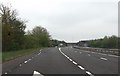
4
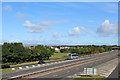
A78 Irvine Bypass
Viewed from B7081 Annick Road
Image: © Leslie Barrie
Taken: 14 Sep 2013
0.08 miles
6
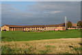
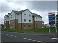
Menzies Irvine Hotel
Originally the Thistle Hotel
Image: © Johnny Durnan
Taken: 6 Oct 2008
0.09 miles
7
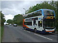
Annick Road (B7081)
Stagecoach No. 11 bus heading for Ardrossan.
Image: © JThomas
Taken: 23 May 2021
0.09 miles
8
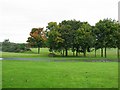
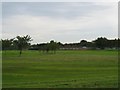
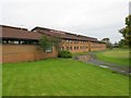
Menzies Hotel, Irvine
It has its own golf course and is a 15 minute walk from the town; it was formerly known as the Thistle Hotel
Image: © Kenneth Allen
Taken: 15 Sep 2007
0.09 miles
10
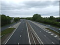
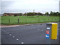
A78 northbound, Irvine
From the bridge on Annick Road (B7081).
Image: © JThomas
Taken: 23 May 2021
0.10 miles