IMAGES TAKEN NEAR TO
Gullane Court, IRVINE, KA11 4DN
Introduction
This page details the photographs taken nearby to Gullane Court, KA11 4DN by members of the Geograph project.
The Geograph project started in 2005 with the aim of publishing, organising and preserving representative images for every square kilometre of Great Britain, Ireland and the Isle of Man.

There are currently over 7.5m images from over14,400 individuals and you can help contribute to the project by visiting https://www.geograph.org.uk
Image Map
Images are licensed for reuse under creativecommons.org/licenses/by-sa/2.0
Notes
- Clicking on the map will re-center to the selected point.
- The higher the marker number, the further away the image location is from the centre of the postcode.
Image Listing (11 Images Found)
Images are licensed for reuse under creativecommons.org/licenses/by-sa/2.0
Image
Details
Distance
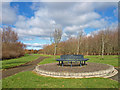
1
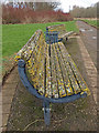
Milgarholm Park, Irvine
Park benches, not fully utilized I think!
Image: © wfmillar
Taken: 10 Mar 2009
0.12 miles
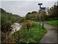
2
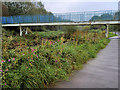
Footbridge across Annick Water
This Footbridge Leads to the Tarryholme Houses which are out of the right side of this photo, and as Annick Water runs out of the bottom left of this photo it soon joins with the River Irvine
Image: © Ian Rainey
Taken: 19 Apr 2006
0.12 miles
3
Annick Water, Irvine
Footbridge from Tarryholme across the water to Milgarholm Park.
Image: © wfmillar
Taken: 10 Mar 2009
0.14 miles
4
Milgarholm Park, Irvine
Circular park bench.
Image: © wfmillar
Taken: 10 Mar 2009
0.15 miles
5
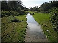
Flooded path, Milgarholm Park
There was a lot of waterlogged ground along the Annick Water after a period of wet weather.
Image: © Richard Webb
Taken: 9 Sep 2009
0.16 miles
6
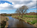
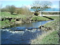
Annick Water, Irvine
The Annick joins the River Irvine. Milgarholm Park on the right.
Image: © wfmillar
Taken: 10 Mar 2009
0.16 miles
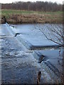
9
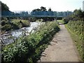
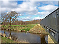
Footbridge, Annick Water
The riverside path is used by National Cycle Network route 73.
Image: © Richard Webb
Taken: 9 Sep 2009
0.23 miles