IMAGES TAKEN NEAR TO
Carnoustie Place, IRVINE, KA11 4DH
Introduction
This page details the photographs taken nearby to Carnoustie Place, KA11 4DH by members of the Geograph project.
The Geograph project started in 2005 with the aim of publishing, organising and preserving representative images for every square kilometre of Great Britain, Ireland and the Isle of Man.

There are currently over 7.5m images from over14,400 individuals and you can help contribute to the project by visiting https://www.geograph.org.uk
Image Map
Images are licensed for reuse under creativecommons.org/licenses/by-sa/2.0
Notes
- Clicking on the map will re-center to the selected point.
- The higher the marker number, the further away the image location is from the centre of the postcode.
Image Listing (11 Images Found)
Images are licensed for reuse under creativecommons.org/licenses/by-sa/2.0
Image
Details
Distance
7
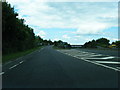
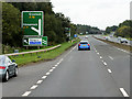
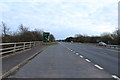
Slip road from the A78 to the A71 at Warrix Interchange
Image: © Colin Pyle
Taken: 4 Jun 2013
0.15 miles
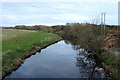
10
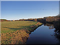
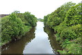
River Irvine
Taken from the A78 bypass bridge.
Image: © wfmillar
Taken: 30 Nov 2009
0.20 miles