IMAGES TAKEN NEAR TO
Sharpe Avenue, IRVINE, KA11 4BH
Introduction
This page details the photographs taken nearby to Sharpe Avenue, KA11 4BH by members of the Geograph project.
The Geograph project started in 2005 with the aim of publishing, organising and preserving representative images for every square kilometre of Great Britain, Ireland and the Isle of Man.

There are currently over 7.5m images from over14,400 individuals and you can help contribute to the project by visiting https://www.geograph.org.uk
Image Map
Images are licensed for reuse under creativecommons.org/licenses/by-sa/2.0
Notes
- Clicking on the map will re-center to the selected point.
- The higher the marker number, the further away the image location is from the centre of the postcode.
Image Listing (31 Images Found)
Images are licensed for reuse under creativecommons.org/licenses/by-sa/2.0
Image
Details
Distance
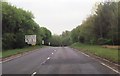
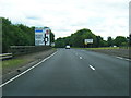
3
Eastbound A71 approaching Corsehill Mount Roundabout
Image: © David Dixon
Taken: 27 Sep 2019
0.13 miles
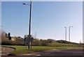
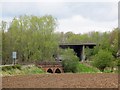
6
River Irvine
View towards Holmsford Bridge Crematorium (the white building amongst the trees centre frame).
Image: © wfmillar
Taken: 17 Aug 2010
0.18 miles
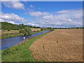
7
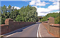
Holmsford Bridge
Road bridge over river Irvine.
Image: © Scott
Taken: 19 Aug 2012
0.19 miles
8
Holmsford Bridge
B730 heading over the River Irvine to Dreghorn. The A71 flyover in the distance.
Image: © wfmillar
Taken: 17 Aug 2010
0.19 miles
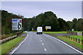
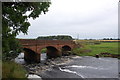
9
Holmsford Bridge
The river bridge is somewhat dwarfed by the A71 flyover in the background.
Image: © Richard Webb
Taken: 25 Apr 2014
0.20 miles