IMAGES TAKEN NEAR TO
Overtoun Road, IRVINE, KA11 3BJ
Introduction
This page details the photographs taken nearby to Overtoun Road, KA11 3BJ by members of the Geograph project.
The Geograph project started in 2005 with the aim of publishing, organising and preserving representative images for every square kilometre of Great Britain, Ireland and the Isle of Man.

There are currently over 7.5m images from over14,400 individuals and you can help contribute to the project by visiting https://www.geograph.org.uk
Image Map
Images are licensed for reuse under creativecommons.org/licenses/by-sa/2.0
Notes
- Clicking on the map will re-center to the selected point.
- The higher the marker number, the further away the image location is from the centre of the postcode.
Image Listing (14 Images Found)
Images are licensed for reuse under creativecommons.org/licenses/by-sa/2.0
Image
Details
Distance
1
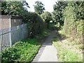
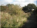
National Cycle Network route 73
It uses the trackbed of the Kilmarnock and Irvine line. View westward after crossing Overtoun Road. Overtoun Road originally used a bridge to cross the railway. There was a junction here with a mineral line running off to the south.
Image: © Richard Webb
Taken: 9 Sep 2009
0.08 miles
2
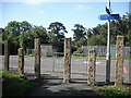
National Cycle Network route 73
Using the trackbed of the Kilmarnock and Irvine line, the cycle path crosses Overtoun Road, Springside. Signs advise of a shop off route in the village.
Image: © Richard Webb
Taken: 9 Sep 2009
0.08 miles
5
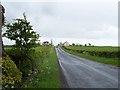
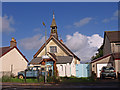
Springside
Viewed from the north on the minor road from Warwickdale Farm.
Image: © Thomas Nugent
Taken: 25 May 2006
0.18 miles
8
Irvine and Kilmarnock Line
A cycle path on the trackbed of the Irvine and Kilmarnock Line (Glasgow and South Western Railway). Looking eastward from near Springside. The overgrown strip of former railway land appears wide here suggesting that there were sidings here.
Image: © Richard Webb
Taken: 9 Sep 2009
0.22 miles
9
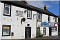
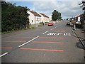
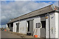
Scott's Corner, Springside
Pub for sale
Image: © Leslie Barrie
Taken: 14 Sep 2013
0.23 miles
10
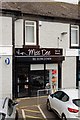
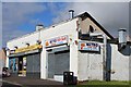
Miss Dee - Springside
Previously Scotts Corner Pub now several shops
Image: © Ian Rainey
Taken: 28 Mar 2019
0.23 miles